Travel to Slovenia
Day 2 Venice - Triglav N.P. - Bled (258 Km.)
We left Venice early to visit the Triglav National Park. To do this we take the motorway towards Austria, but we turn off in Udine towards the border crossing of Stupizza, 138 km from Venice. We entered Slovenia and after passing through Kobarid, we approached Bovec. 7 kilometers before this town, at the point of Žaga, we have the Boka waterfall.
(in 164 Km.) Boka (Slap boka): It is the most powerful and highest waterfall in Slovenia. The total height of its two falls is 106 meters and 18-20 meters wide. The water flows at an amount of 100 cubic meters per second (depending on the time of year). Access: Easily seen from the Bovec-Kanin highway, from Žaga. The sensation at the base of the waterfall takes your breath away. The access by the margin of the river is very complicated.
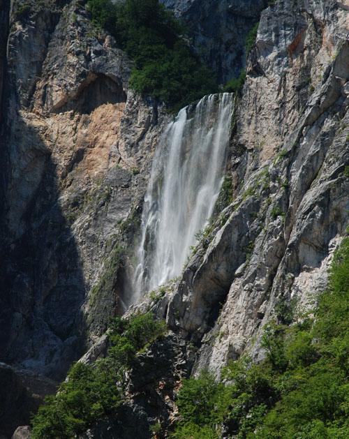
Slap Boka - Boka Waterfall
(in 7 Km.) Bovec: Highlights the cable car that goes up to Kanin, the only ski resort in Slovenia that has slopes at 2,000 meters above sea level. The Kanin station is located above the village of Bovec, known worldwide for the Soca river. Kanin is an alpine ski resort where the ski season lasts from December to the beginning of May. The slopes are accessed by a 6 km long gondola lift, which was renovated in 2003. The station is known for being sunny, and for the breathtaking views: from the heart of the Julian Alps to the Adriatic Sea. The peculiarity of Kanin is the ability to ski in three countries: Slovenia (Kanin), Italy (Sella Nevea and Tarvisio) and Austria (Arnoldstein).
(in 4 Km.) Kluze fortress: Located above the deep canyon of the Koritnica river, it is located 4 km from Bovec, in the direction of the mountain pass of Predel. The fortress - which began as a small wooden fortification - was built in the second half of the 15th century for the purpose of preventing Turkish looting in Carinthia. Georg Philipp von Gera, the sovereign of the Bovec region from 1613-1643, discovered in 1613 a spring of water near the stone fortress he was building. This allowed his troops to survive during the longer sieges. Near the fortress there is currently a commemorative plaque that shows the coat of arms of Georg Philipp von Gera and the year of construction of the fortress.
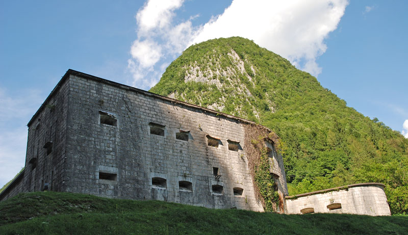
Trdnjava Kluže - Kluže Fortress
In 1797 the Austrian troops defended the fortress against the French troops, who had previously defeated them in northern Italy, under the command of General Napoleon Bonaparte. That is why the Austrians, seeing that they had little chance of defeating the French, withdrew at night the bridge that crossed the Koritnica River so that many French soldiers fell into the water. The next day, the Austrian army had to surrender and the French as a sign of their fury over the aforementioned event destroyed the fortification.
The current image of the fortress dates from 1882. Its central part has a square shape, with narrow and elongated embrasures in the walls. The complex also includes the upper fortress of Fort Hermann, erected on the crest of the mountain. The road that reaches this fortress begins carved into the rock and then continues through a tunnel. The fortress of Fort Hermann was destroyed during World War I, while the Kluze fortress - located on the side of the road - was not destroyed by the Italian artillery. The defensive wall of the Kluze fortress that blocked the pass, had to be destroyed to make the current road. Allied forces rebuilt the bridge over the Koritnica river between 1945 - 1947.
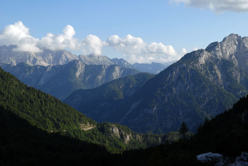
After leaving Bovec we enter the Triglav National Park. The Triglav National Park stretches along the Italian border and very close to the Austrian border in northwestern Slovenia. It practically coincides with the eastern Julian Alps. The highest point of the park is the Triglav (2,864 masl) and the lower one, the Tolminka gorge (180 masl). The landscape is dominated by the folds of the eastern Julian Alps, with pointed summits, steep slopes and deep glacial valleys.
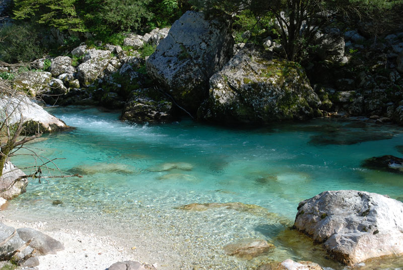
korita Soce - Gorges of the Soca River
The forests extend for two thirds of the territory of the park, predominating beech trees in the southern part of the park. In the northern part, spruces and larches predominate. Throughout the area there are karstic springs, water courses and glacial lakes. The ridge that lies between the Sava and the Soca marks the watershed between the Mediterranean and the Black Sea. The eastern slopes of the alpine range have peaks of almost 3,000 meters, with meadows and forests ideal for hiking. The most well-known canyons of the Soca river are near the town of Soca.
(in 12 Km.) Soca: Just after crossing the village of Soca (7.5 km from Bovec) we find the Grand Canyon of the Soca River (Velika korita). It is 750 meters long, 15 meters deep and in the narrowest areas it is only 2 meters wide. Between Trenta and Soca, the Soca River sculpts the Small Canyon (Mala korita) with 100 meters long, a depth of up to 6 meters and 1 meter wide in the narrowest parts. It is accessed from the road from Bovec to Trenta. Right after Kal-Koritnica there is a sign on the road marking the entrance to the Triglav National Park. Just after the sign (inside the park) there is a path that leads to a bridge next to the different pools.
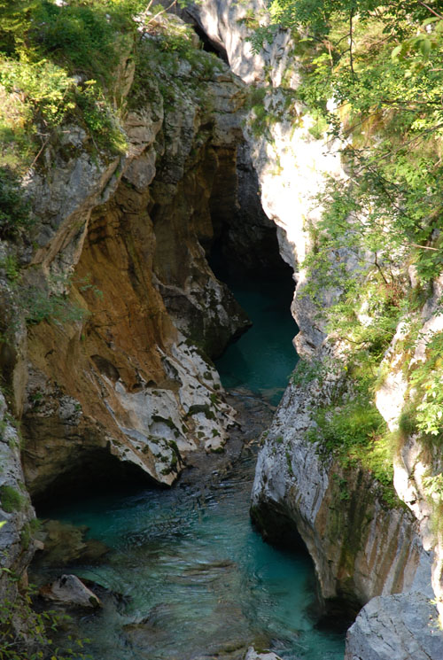
korita Soce - Gorges of the Soca River
(in 9 Km.) Trenta: The Trenta Valley is a horseshoe-shaped valley, deeply sculpted between the mountains, with diversity of wild canyons. Through these canyons flow to the river Soca the waters of the river Mlinarica, Krajcarica -whose water appears and disappears again and again without losing its strength-, Vrsnik -with its emerald green wells- and Lepenjica, that crossing big boulders reaches Soca . In Zadnja Trenta, the most distant part of the valley is the Zapotok basin with a height of 180 meters where the highest waterfall of the Triglav National Park falls. We can also visit the sources of Soca at the point of this town.
Vršic - Vrsic pass
(in 10 Km.) Vršic: We cross the Vršic pass (1,611 meters). This cobblestone road was built in the spring of 1916 by more than 10,000 Russian prisoners of war. Judging by the peace that now breathes in this place, nobody would say that the area surrounding the Vršic pass was one of the main war fronts between Austrians and Italians during the First World War. We continued to another of the attractions of the park. It is the road that goes from Bovec to Kranjska Gora, crossing the Vršic pass, located in the Julian Alps. From this point, the road descends on one side (for which we just climbed) towards the source and valley of the Soca River (which finally flows through Italy, where they call it Isonzo, on its way to the Adriatic), and by the other side we go towards Kranjska Gora and Bled. The road has fifty numbered curves of 180 degrees.
Ajdovska deklica, 1 Km from Zapodnem. From the Vrsic pass you can see this curious figure on the Prisojnik wall, the "Ajdovska deklica". Legend has it that it is the face of a girl named Ajdovska Deklica who predicted the fate of newborns in the region, and one of her predictions punished her by turning her into a rock.
From this point we descend in a zigzag to 1,100 meters, where the Russian chapel (Ruska Kapelica) is located, a small wooden church erected in the place where 400 Russian prisoners died because of an avalanche. Right next to it there is a tomb with a pyramid where you can read "To the children of Russia".
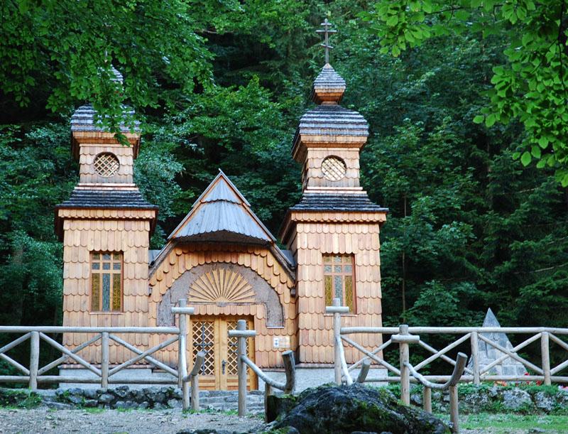
Ruska kapelica - Russian Chapel
(a 10 Km.) We stopped at Lake Jasna (Jezero Jasna), located 2 km south of Kranjska Gora. It is a lake of glacial waters with white sand on its banks. We can find a bronze statue of the irascible Zlatorog, a mythical goat with golden horns that guards the treasure of the mountain.
(in 18 Km.) Although we did not have time, you can finish the visit at the Slap Pericnik waterfall, in the Vrata valley. Once we get to Mojstrana we take the road to the Vrata valley. Next to the waterfall there is a parking lot from which you can see the waterfall. It is one of the most well-known waterfalls in Slovenia. The most interesting thing of this waterfall is that you can pass by walking behind it. It is formed by two waterfalls. The upper one is 16 meters high and the lower one is 52 meters high. To be able to climb the upper cascade, one must be very careful. The best views of the waterfall are obtained from the hill that is right in front.
(in 28 Km.) Bled: We arrived at this town that we used as the first base camp to explore the area. We slept in Penzion Bledec , a simple, economical hostel and above all very cozy, with bathroom in most rooms (with bunk beds). The best is his restaurant, with menus of 8 euros (a soup, a salad, a third main course and dessert) Totally recommended for those who do not look for great luxuries.