Travel to Canada
Day 6 Jasper - Field (254 Km.)
Jasper: Early we visit the attractions near the town of Jasper. It owes its foundation to the passage of the railway in 1911, but before there was already a small settlement for workers of the Grand Trunk Pacific Railroad who were building a road along the Athabasca River valley. The village itself is not very interesting, but perfect as a base for visiting Jasper National Park. The arrival of the railroad and the transformation of parks resorts were almost at par, and the city grew to include hotels and restaurants.

Jasper
North of town are the Pyramid Lake and Patricia Lake, located under the Pyramid mountain, with a height of 2763 meters. On the other side of town are lakes Annette, Edith and Beauvert. Along the last one is the Jasper Park Lodge, consisting of fifty houses scattered throughout the lake. It is rival in luxury with the Banff Springs hotel, and is highlighted by ponds and golf course. Nearby is the Old Fort Point, which is not known with certainty their age and offers views of Jasper and the Athabasca River.
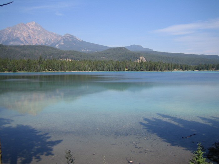
Jasper - Beauvert Lake
Because we haven´t enough time, we don´t visit Mount Edith Cavell, which is accessed by a winding road. We gone towards the Athabasca Falls, 30 kilometers from Jasper. Although it is not one of the largest falls (23 meters), it highlights by the strength with which it falls on the Athabasca River gorge. It is also easily accessible because it is less than 50 meters from the Icefields Parkway. Twenty five kilometers to the south are the Sunwapta Falls. At this point the waters of Chaba Valley fall on the Athabasca Valley, a waterfall formed by several falls which have scratched in the limestone a deep canyon.
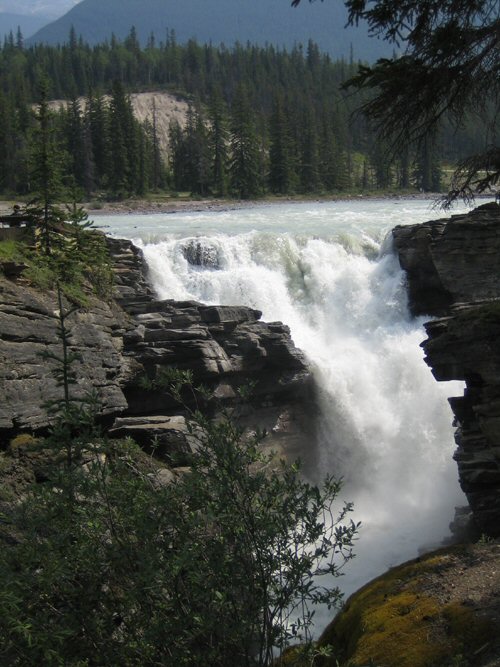
Athabasca Falls
Athabasca glacier is the most accessible of the glaciers that fall from the Columbia Icefield, and which almost reaches the Icefields Parkway, where is the Icefield Centre. At this point, the route of the icefields enters in the Jasper National Park, the largest and most northern Rockies. The field was created during the last glaciation. About 10,000 years ago, ice covered the region and carved wide valleys, walls cut into the mountains and steep peaks. In the access road at the base of the glacier can be seen the distance the glacier has receded over the last hundred years (several posts indicate the exact location where the glacier front had reached in the last hundred years.)

Athabasca Glacier
One of the most popular excursions is that of the Ice Explorer. It consists of several buses leaving every fifteen minutes of the Icefield Centre to a transfer point next to the Athabasca Glacier. From there, we board on a special off-road vehicles that reach the heart of the Athabasca Glacier. Once there you can step off the vehicle and walk over the glacier ice (within a marked area). The trip lasts a total of one hour (more or less 20 minutes on the glacier), but can be lengthened in the peak periods due to queues. The Columbia Icefield is the largest accumulation of ice in North America and covers an area of 325 square kilometers, taking in some places a depth of between 300 and 360 meters. Another curiosity of this glacier is that its melting water reaches three different oceans: Arctic, Atlantic and Pacific.

Athabasca Glacier
El Icefields Centre posee un centro de interpretación interactivo que explica la glaciación y el impacto de los glaciares en el paisaje de las Rocosas, además de ofrecer información sobre rutas por la zona. Dispone de diversos servicios turísticos, restaurantes, bares y tiendas. Existe un mostrador con personal del parque nacional que ofrece información del área, de los sitios de acampada, del parte metereológico, etc. También existe un puesto de primeros auxilios.
The Icefields Centre has an interactive interpretive center that explains the ice age and the impact of glaciers on the landscape of the Rockies, as well as providing information on routes in the area. It has various tourist services, restaurants, bars and shops. There is a counter with national park staff that provides information about the area, camping sites, the weather forecast, etc. There is also a first aid station.