Travel to Ireland
Day 7 Ballycastle, Achill Island (307 Km.)
(in 83 Km.) Downpatrick Head: We pause our route to take our daughter to Ballycastle, in Mayo County, to study English. We take advantage of the proximity to go see Downpatrick Head. From the top of the cliffs of Downpatrick, which had a church dedicated to St. Patrick, we see a cliff, called Dún Briste (the Broken Fort), 45 meters high, in which the different levels of strata are perfectly observed. Downpatrick also stands out for having been a lookout post (Eire 64) during World War II, Another of the curiosities of this place is Poll Na Seantainne (Hole of the old fire), an area where the erosion of the waves on the weaker rocks caused a collapse and through the hole created you can see the sea.
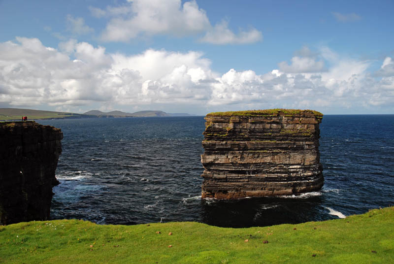
Downpatrick Head
(in 14 Km.) Ceide Fields: The Céide Fields (Irish: Achaidh Chéide, meaning "flat topped hill fields") is an archaeological site on the north County Mayo coast The site is the most extensive Neolithic site in Ireland and contains the oldest known field systems in the world. Using various dating methods, it was discovered that the creation and development of the Céide Fields goes back some five and a half thousand years (~3500 BCE). Investigations revealed a complex of fields, houses and megalithic tombs concealed by the growth of blanket bogs over the course of many centuries. The site is in UNESCO's tentative list to gain World Heritage status. Due to lack of time we didn't visit this place. Just in front of the parking lot there is a viewpoint over the cliffs.

Ceide Fields
(in 87 Km.) Achill island: Achill Island, with its 147 square kilometers, is the largest in the country among the islands surrounding the main island of Ireland. It is linked by the Michael Davitt bridge, which links the villages of Gob an Choire (Achill Sound) and Poll Raithní (Polranny). One of its main attractions is the abandoned town of Slievemore (Deserted Village): a settlement of at least 100 traditional stone constructions, which dates back to the Anglo-Norman period and remained inhabited until the early twentieth century. Taking advantage that we have a sunny day, we drive to the westernmost part of the island in order to take a bath in the Keem beach. Despite the good temperature, we discovered why all the children bathed in wetsuits: the water was freezing!

Achill island - Keem Bay
Near the westernmost point of Achill, Achill Head, is Keem Bay. South of Keem beach is Moytoge Head, which with its rounded appearance drops dramatically down to the ocean. From Keem beach starts one of the most popular excursions on the island, the ascent to Mount Croaghaun (666 m). The cliffs of Croaghaun on the western end of the island are the third highest sea cliffs in Europe but are inaccessible by road. We start the way back through the narrow Keem Strand, which advances along the edge of the cliffs, offering spectacular views. In the lively town of Keel is another very popular beach, the Keel beach, to the east of which we can see the cliffs of Cathedral Rocks.

Achill island
We ascend an area of peat bogs and when we reach Cashel we can take the turnoff that goes up to Minaun Heights, a 464 meter high hill that offers views over the whole island. If we continue along the southern coast road we can see one of the towers of Grace O'Malley.
(in 53 Km.) Wesport: On the way to our accommodation we cross Wesport, one of the most interesting cities in Ireland, in which the Octogon square, the tree-lined walkway The Mall, next to the Carrowbeg River, the Holy Trinity church and the pubs located on Bridge street stand out.
Oughterard
(in 70 Km.) Oughterard: After a long day, we reach this lively town where we have our accommodation. We went out to look for a place to have dinner and found a wide offer. Located along the west shore of Lake Corrib, there are other tourist attractions such as a golf course, the Glengowla Mines or the ruins of Aughnanure Castle, a well-preserved example of a Norman tower house.